How Drones are Changing Construction Sites
By now, there's no denying it—drones have made their way into the construction industry.

By now, there’s no denying it—drones have made their way into the construction industry.
By now, there’s no denying it—drones have made their way into the construction industry.
By now, there’s no denying it—drones have made their way into the construction industry.
Today’s drones pack a big punch, helping project managers, site engineers and virtual design and construction teams build instant return on investment with jobsite-ready maps and models. Time and again, drones save money, reduce downtime and improve safety on construction projects.
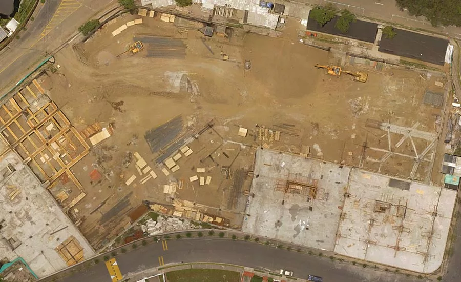
Drone maps are proving to be incredible tools on job sites, enhancing nearly every aspect of a project from ideation to completion, including communication, inspection and safety. At some companies, where commercial drone software is built, construction customers use drone maps to solve some of the industry’s toughest problems.
Improve Team Collaboration
One of the most visible ways that drone mapping can benefit project managers on construction sites is by giving a big-picture view of the project and its progress. These images, especially when annotated, are invaluable for keeping team members, contractors and stakeholders abreast of the project.
Project managers often post weekly drone maps in the project trailer to show all parties a clear picture of the job site and progress over time. With tablet and smartphone integrations, design changes can be relayed to invested parties in seconds via a single image, versus days of back and forth.
Catch Problems Sooner
Industry integration means that drone maps can be used in collaboration with software like building information models, geographical information systems and computer-aided design.
One customer, Tilt Rock of Texas, works on large custom residential projects and overlays drone maps with utility, wastewater and communications plans to catch conflicts with services before they actually happen, saving time and money.
Project managers are also using drone maps to monitor sub-contractors. For instance, our customer Brasfield & Gorrie uses drone mapping to keep tabs on contractors who complete earthwork. Using DroneDeploy, they monitor the site grade via drone, saving days on data collection.
Drones can also improve jobsite safety by identifying hazards before they become liabilities— reducing the time workers have to be on the ground, walking in often dangerous areas or inspecting elevated structures.
Quickly Plan the Next Phase
Drone mapping also makes it easy to calculate the square footage of roofing materials required, how much square footage of concrete is still needed to pour or how much debris has to be cleared to give a truck clear site access.
The Future of Construction
In the coming years, drones won’t just be a time saving tool. They will be an essential component of the construction industry and integrated into nearly every aspect of the job, from job site communication and site safety checks to seamless BIM. Through the application of machine learning and artificial intelligence, check-ins will be automated and data will be verifiably accurate—leading to safer and more efficient job sites around the world. If you haven’t already looked into drones, now is the time to start learning how to put them to work on your job site.
Whether you’re minimizing risk, increasing productivity, monitoring progress or enhancing communication, drone maps are revolutionizing construction sites.
Looking for a reprint of this article?
From high-res PDFs to custom plaques, order your copy today!


